Showing posts with label camping. Show all posts

Monday, February 28, 2011

More Adventures in the White Mountains

This weekend, Jaimee and I spent another wonderful weekend in the winter wonderland of the White Mountains. We stayed for two nights at Carter Notch Hut near Mt. Washington. We drove up on Friday and when we left Boston it was a hard rain that turned to snow as we progressed north. It took over six hours to drive there, more than double what it should take. This meant we got a late start hiking, leaving the trailhead at 4:15PM for the four mile hike to the hut.
We made good time on the slog up the Nineteen Mile Brook trail, but when we got to the top of the ridge, it was pitch black with a hollowing wind. Even with our headlamps on full blast we could barely see in front of us, and when we got to a trail sign that said the hut was 0.3 miles we were super excited. The problem was, with the blowing wind, there was no trail. Having never been to the hut before we didn't know that it sat just above two small lakes. All we found were the lakes, and as we wondered across the frozen surface we noticed that our tracks were blown away so it was impossible to backtrack. I'll skip to the ending in that we eventually noticed the lights from the hut, but I will say, I was very, very scared. The White Mountains are a dangerous place, especially in the winter, at night, in a blizzard. It was the first time I'd ever seriously contemplated activating the 911 feature on our Spot device, but luckily, we stayed calm, found the last bit of trail that we recognized by walking the perimeter of the lakes and were able to find the path people take in the summer. There was another sign at 0.1 miles from the hut and at that point we could see the warm glow of the hut.

Our two-night stay at the hut was fairly uneventful, except for a drunk person in our bunk room. We stayed in a six-person bunk house the first night and one of our bunk-mates threw up inside the room, multiple times. It's a pretty horrible sound to hear retching and then the sound of vomit hitting the floor. Luckily the room was about 10 degrees so the vomit froze and actually didn't smell. But the guy did cause some drama looking for the door, falling on ice, making all sorts of noise. The second night was less dramatic as we had the room to ourselves.

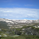
We climbed one 4,000 foot peak during out stay, Wildcat Mountain A, which was quite the hike. It's only one mile up to the summit but because we had to break trail through drifts of snow over four feet high it took us two and a half hours to get to the top and only 40 minutes to come down.
The hike out to the car was much easier than the way in, but we decided to just return the way we came on the Nineteen Mile Brook trail instead of out and over Carter Dome, another 4,000 foot peak in the area. We got back to our car, and although the car was fine, we'd left a Sigg water bottle full of water in the car and when it froze it broke the metal bottle! The weather and conditions of the White Mountains are not be taken lightly!

Other than our little weekend adventure, we've had more quality family time. We celebrated Jaimee's birthday with her cousin and meme, who all have birthdays within a few days of each other. I love this picture of the three of them blowing out the candles on the cake. Take away the smart phone on the table and it could be a Norman Rockwell painting:
We also got in a trip to Vermont to visit my Aunt and Uncle, where Jaimee and I pinch-hit for my Aunt (she hurt her knee and has trouble snow-shoeing) and led the wine and cheese snow-shoe tour at Grafton Ponds where she works. Much easier than hiking up Wildcat Mountain, this was a 45 minute hike through the woods to a waiting bonfire where they'd already brought up bottles of wine and blocks of cheese via snowmobile. We drank four bottle of wine between 10 of us, which made for an interesting walk back down through the woods. We've had an amazing snowy winter here in New England and we feel lucky that we've been able to enjoy it as much as we have.

Tuesday, February 1, 2011

Lonesome Lake

As promised, here's an update of our latest winter adventure at Lonesome Lake hut in the White Mountains (with pictures). It started, like many trips to New Hampshire do, with a stop at the Liquor Store right off the highway. We had to stock up on "nips" to keep us warm in the hut, and we also wanted to pick up some Sortilege, that super-yummy Maple Canadian Whiskey that our Canadian couchsurfers brought us a couple months ago. We couldn't find Sortilege in Massachusetts, but we'd heard it was available in New Hampshire. Sure enough, they had a huge display of it, although they were the small 375mL bottles which was disappointing, but it just meant that we got two!

The hike into Lonesome Lake hut is fairly short, a little over a mile, but like many trails in the White Mountains it is very steep - it gains about 900 feet in that one mile so it was a good workout. The lake was completely frozen over so we could take a shortcut across it to get to the hut:
The setup of the hut is a large main building where the caretaker keeps a wood fire in the evenings surrounded by two unheated bunk houses separated into rooms with four or six beds each. The entire compound sleeps about 45 or so, but when we got the hut, the very nice caretaker told us it was only us and one other couple that night. So we had privacy on our anniversary after all. We soaked it up that first night because on Saturday night the hut was filled to capacity, half of them a "Women of Newburyport" group. They certainly took advantage of the short hike in as they carried in at least a dozen bottles of wine.

Our friends Michael and Liza met us at the hut on Saturday morning and we did a day hike of two 4,000 foot peaks in the area. The conditions were amazing. The trail was already packed out by other snowshoers and although there wasn't much sun, there also wasn't any wind so it wasn't all that cold (as long as you kept moving). It truly was a winter wonderland. We summited both North and South Kinsman, making it peaks 17 and 18 in my quest to hike all 67 4,000 foot peaks in New England.
Even though supposedly the hut was packed the second night, no one shared our bunk room with us so we had the room to ourselves again. Of course, the temperature in the room was in the single digits so we didn't spend too much time in the room itself; mostly we were bundled up in our sleeping bags. I'm a pretty warm sleeper so I was comfortable in my 25 degree down bag, while Jaimee had borrowed her dad's 0 degree bag. It took up most of her backpack on the hike in and out but she claims it was totally worth packing in.
We had a great weekend at the hut, and I'd totally recommend Lonesome Lake as a place to try out "winter camping" as it's a short hike in, the hut is very comfortable (even with 40 or so people), and the setting is beautiful. We're already planning our next outing, probably to Carter Notch Hut at the end of February. 

Friday, December 31, 2010

A Winter Adventure

With this posting I may have to really rethink the whole "Chasing Summer" title for this blog. I just spent three days enjoying the aftermath of the "Blizzard of 2010" up in the White Mountains of New Hampshire. (Jaimee could not go with me as she had to work.) Last Sunday night New England, especially coastal areas like Boston got hammered with snow. Boston alone received 18 inches of snow. Before the storm, we spent Christmas Eve to Christmas morning at Jaimee's dad's house in Shrewsbury. We had a lovely, festive time, and pardon the inside joke (but let's be honest, only "insiders" are really reading this anyway) no churches were burned down on Christmas Eve. We left Shrewsbury Saturday evening and drove down to Cape Cod where we visited with Jaimee's visiting Mom and her brother and sister. The storm began rolling in late Sunday morning, and although we had plans to return to Boston on Sunday night, we spent another night and braved the roads back to Boston on Monday. Although by Monday most of the snow had fallen, the roads were still somewhat treacherous and parking in the city was a nightmare. Our downstairs neighbors were out of town so they said we could park in their driveway, but that meant I had to shovel it. It took over two hours to shovel out the driveway wide enough to park the car. Dealing with this much snow is certainly never something we had to deal with in Seattle.

However, the timing of the storm couldn't have been better with respect to my planned trip up to the White Mountains. I spent two nights with our friends Liza and Michael at the AMC Zealand Falls Hut. The hut is rustic, only heated with a wood stove that they stoke between 4PM and 9PM each day. The hut has bunks for about 35 people and it was filled to capacity each night. This meant for cozy accommodations especially in the main room with the stove. We had a great time though, playing games and meeting new people. Not only did I meet someone who knew one of the Appalachian Trail through-hikers I met last summer while hiking the Long Trail, but I also met people who knew my Aunt and Uncle, Neil and Betsy. One guy said he'd house sat for them, and another said he used to work at the West Hill Bike Shop when my uncle owned it. It truly is a small world.

We also got in lots of snowshoeing during the day. The first day was a relatively easy snowshoe into the hut because the trail was already broken out. The second day we took the trail up to Zealand Mountain which was not already broken out. It took the three of us five hours to break through snow that was often up to our waist deep. We eventually got to the summit, which sadly had no view. Although it is a 4,000 foot peak so it helped my friend Michael who is attempting to climb all 48 of New Hampshire's 4,000 foot peaks in the winter:


The third day we returned to the car via the summit of Mount Hale, another 4,000 foot peak. Again, waist high snow where we took turns breaking trail to reach the summit. Hale actually had somewhat of a view and the day was beautifully sunny, so we enjoyed basking in the warm and calm summit:

It was a lot of work snowshoeing through the mountains, but it was a ton of fun and I hope to get up to the mountains more this winter. I'm not necessarily trying to climb all 48 New Hampshire 4,000 footers in the winter, but I am keeping track of which ones I've climbed; I'm up to 16 peaks climbed (and now two in the winter). You can see the rest of the pictures from my hut adventure here.

Now we're finishing packing up and are headed to Neil and Betsy's for the weekend. We might get in some cross-country skiing, but overall hope to have a relaxing New Year's. 2010 was a tremendous, life-changing year for me and Jaimee and I'm hoping 2011 brings more adventures and fun!

Saturday, September 18, 2010

An Adirondack Adventure

Things really came together for us since our last post. For starters, I was offered a job at one of the places where I'd interviewed. Prior to our trip to Seattle, I'd given the company my list of references but because of the holiday (and because I knew some of my references were on vacation) I wasn't sure how quickly they'd be able to contact them and then make me offer. However, when we landed in Boston from Seattle I had a message from the recruiter with my verbal offer. We made it official via e-mail the next day. My start date is this coming Monday, September 20. I'm excited for the job. I'll be working for an Internet Marketing company doing some programming and data manipulation. I'm excited because their primary programming language is Python, a language I've never used before. I'm really glad they trusted that I'd be able to learn it quickly enough.

Second, we found an apartment! As we might have alluded to in this blog, apartment hunting in Boston was a real challenge. We looked at dozens of places, but apart from one place where someone else rented it between us seeing it and telling the landlord we wanted it, none of the other places grabbed us. Until we saw a really cute third-story attic apartment, advertised on craigslist as the "tree-house apartment". It's the top story of a three-unit building in the Roslindale neighborhood of Boston. It's essentially a big studio apartment with five large sky-lights and plenty of closets. It's within our budget (although more than we were paying in Seattle, for less space too) and it's within walking distance of both Roslindale village, with numerous shops and restaurants, and the commuter rail station where I'll be just a 12 minute train ride to my new office (the office is on the 7th floor above the train station at Copley Place in Boston). We'll show some pictures after we move in on September 25.

So, with the job and apartment all squared away, we decided to take a mini-vacation during our last week of "freedom". We drove up to the Adirondack Mountains in upstate New York for what we thought might be a few nights of camping. Our main purpose in going up there was to climb Mount Marcy, the highest point in New York state. Unfortunately, we did very little planning with regard to the trip so it didn't work out quite how we would have liked.

For starters, it took a long time to get there, and we got kind of a late start so we didn't get to the area until after dark. Then, the campground we'd planned on going to was closed for the season. Since Mount Marcy is really close to Lake Placid, there were plenty of hotels, but none were very cheap. We found a little "cabin" in nearby Saranac Lake, which was habitable but full of mouse poop and if we turned on the gas heater we felt like we were going to get asphyxiated. We ended up sleeping on the bed in our sleeping bags, although we did use the little gas stove to cook our camping food.
From Mt Marcy
The next day we climbed Mount Marcy, which was a 15 mile round trip hike with about 4,000 feet of elevation gain. As mentioned, it's the highest point in New York (and therefore all the Adirondacks) at 5,344 feet. Despite the length, the hike was pretty easy, except for the summit push which was quite steep and the top was very windy and cold. We took a few quick pictures and headed back down.
From Mt Marcy
In addition to being a state highpoint, Mount Marcy has historical significance as well. In 1901, Theodore Roosevelt was camping in the area when President McKinley was assassinated. He was summoned to take over and he then became the youngest President ever at 42 years old. (President Kennedy would later become the youngest elected President at 43 years old).

There was a campground at the base of the mountain, but they charged $40 per site to camp! Plus, "room tax" of 10% and $10 a day to park! That would add up to $54 to camp for the night. Seriously? Even though that was cheaper than a hotel room (or cabin) nearby, we felt that was a ridiculous amount to pay for camping. So we left and got a hotel room in nearby Lake Placid. We probably violated all sort of regulations but we cooked up our camp food on our camping stove inside the hotel room.

We then came back to Massachusetts, stopping for one night to visit my lovely Aunt Lisa and Uncle Dick in Catskill, New York on the way. We had a quick visit, but we enjoyed catching up with them and having a nice dinner. We came back to some sad news regarding Jaimee's family though. Her grandfather spent the day after his 90th birthday in the intensive care unit of the hospital. He'd been having various health problems over the past few months, but he got a bladder infection that sent him to the hospital. We visited him at the ICU and he was not doing that well, barely aware of his surroundings. As of this writing he's still there and hanging on, and we're all hoping that he can pull out and survive the infection.

Thursday, August 12, 2010

Long Trail Report - Week 1

I'm happy to report that I made it through Week 1 of my Long Trail hike. I came off the trail after five and a half days and 85 miles in order to come back to Boston to do some job interviews. Yes, reality is starting to slowly settle in. After the interviews tomorrow and early next week, I hope to get back on the trail.

The first week was awesome. My cousin Bevan joined me for the first three days and we had a great time walking through the woods. Here we are getting dropped off at the Appalachian Trail in Williamstown, Massachusetts. (The Vermont border and official start of the Long Trail is 4.1 miles away):
There are three-sided shelters every five to 10 miles along the trail, so I based how far I'd go each day on which shelter I wanted to stay in that night. Bevan carried a three (!) person tent for the sections with me, which we used one night. The second night together we stayed in one the shelters. The scenery we walked through was amazing, particularly Glastenbury Mountain. There's an old Fire Tower on top and the views over all the Green Mountains were very nice.
Bevan even found his 700th geocache up near the Fire Tower. Good work Bevan! After his wife Tammi picked him up on the third day, I resupplied from a stash in Tammi's car and continued on. I packed a one-person tent and got to use it twice; once I pitched it inside a shelter to double as a mosquito net, and a second time I pitched it outside in the pouring rain. Both times the tent worked like a charm. I camped by a few lakes, including beautiful Stratton Pond, the biggest body of water along the Long Trail. Combined with a climb of Stratton Mountain, it would make a lovely day hike, or short backpacking trip.
Since this beginning part of the Long Trail overlaps with the Appalachian Trail (AT), I got to meet many, many AT thru-hikers. They are a varied and interesting bunch, to say the least. They're also very social for the most part and I enjoyed chatting with them and hearing about their journeys. All the hikers use "trail names" to refer to each other, in many cases they don't even know each other's real names. Since I was only out on the trail for a few days I didn't get a trail name, but when I continue on the Long Trail later, maybe I'll get one. Apparently, you can't name yourself; someone else has to give you the name.

I created a Picasa album of my pictures so far, including a map of where most of the pictures were taken. I'll keep adding to it when I pick up my hike, hopefully next week.

Thursday, August 5, 2010

Off on the Long Trail

I'm headed to Vermont as soon as I finish packing. Tomorrow morning I start my Long Trail hike. My cousin Bevan is joining me for the first three days and then I'll be on my own for the rest. (Unless anyone cares to join me. Anyone? The invitation is out there.) I'm leaving the schedule somewhat open although I created a quick map of my projected route with each day's shelter stop marked on the map. The schedule is subject to change, depending on how I feel each day, but the plan is to stay at a shelter each night. (There are shelters approximately every five to 10 miles so I can adjust the schedule as need be.)


View Long Trail 2010 in a larger map

If all goes according to plan I will spend 18 days hiking with rest days after the first and second weeks (in Killington and Stowe, respectively). Jaimee is planning on meeting me for each of these rest days when I will resupply for the upcoming week. Be sure to check my Spot page as I intend to check-in every night, and if I get Internet access during my off-days I'll update the blog with some pictures of the hike. I'm super excited!

Wednesday, June 9, 2010

Iceland: a beautiful cherry on the top of our trip

Iceland is amazing! I can't imagine a better place for the last stop of our trip. Although we only have four days here, and are just barely scratching the surface of what Iceland has to offer, the scratch that we've done has been pretty nice.

Our visit started out on a slightly stressful note though. We took a 10:30 PM flight from Frankfurt, which was scheduled to arrive around midnight local time (it's about a 3 1/2 hour flight and Iceland is two hours behind Western Europe), but the flight was delayed by about an hour and we didn't arrive until after 1 AM, and after taking the bus into Reykjavik it was almost 2 AM. We had scheduled to stay with a Polish couple through couchsurfing and we had their address and phone number, but it turns out we were dialing the wrong country code. We were using the SIM in our phone that we got in Greece so we didn't know that we had the wrong code, only that the phone number didn't work. After walking around for a while (even at 2 in the morning it wasn't even close to dark) we eventually found the apartment, but after ringing the bell and knocking on the door, nobody would answer! We didn't know what to do, but in the end decided to just "camp" in their yard. We unfurled our beach mat and sleeping bags and slept for a few hours in the back yard.  Around 8 AM we tried ringing the doorbell again and this time they answered. They're not sure why they didn't hear us the night before, but they welcomed us in the morning before heading off to work.

We spent the day exploring Reykjavik, which is a very cosmopolitan town, full of little cafes, restaurants, book stores and other little shops. We were lucky to have a beautiful blue sky day, with temperatures in the high 50s, low 60s. Here's the famous concrete church, called Hallgrimskirkja. We didn't get to climb it because it was busy with funerals, but it's quite a sight and because it's on a hill, it can be seen from all over town:
From Iceland
We also visited one of the many outdoor geothermal public pools. For a 360 kroner ($1.75 US) fee we soaked in a gigantic outdoor hot tub. These pools are everywhere and are centers of social life. Instead of going to a coffee shop (although they do that too) groups congregate and hang out soaking in hot water. It was quite fun.

Iceland has a reputation for being extremely expensive, but Iceland was hit especially hard by the recent financial crisis and their currency took a huge hit (thanks Financial Crisis!), so in dollar terms prices are half or less what they were two or three years ago. So, while Iceland is still not cheap (restaurants in particular are still quite costly), it is not at all prohibitively expensive. For example, we ended up renting a car for two days to do some touring and it cost 19,000 kroner (about $90 $145 US) for two days. This includes taxes and insurance! Update: I realized later I must have miscalculated the exchange, and it's actually $145 for the two days, which is on the high side, but still better than we could find on-line when doing research.

We also scored a free tent for out little excursion by just asking. We went into an outdoor store and inquired about renting a tent to do some camping and although they didn't rent tents they told us to check the hostel across the street. We went in there and asked and they said we could just have a tent! Some German tourists had bought it and didn't want to bring it home so left it at the hostel. We were surprised, but they just let us have it. It's not the best tent in the world, but it was more than sufficient. (See a picture of it in action.)

For our road-trip we toured around what's called the Golden Circle area, a loop of about 200 miles or so that visits some waterfalls, National Parks, hot springs and geysers. Here's a short video of a geyser called Strokkur. It erupts every five minutes or so. You can watch the water recede into it and then bubble up and explode. There were gangs of kids (heard screaming in the background) who would stand downwind from the geyser and get soaked by the water.
From Iceland
We tried to get some pictures of Eyjafjallajokull (no, I didn't fall on my keyboard, that's really how you spell it), the volcano that caused all the flight cancellations last month, but it was covered in clouds so we couldn't see any steam. We also saw plenty of huge waterfalls, including Gullfoss, which had a beautiful rainbow across it:
From Iceland
We've had a blast (no pun intended) touring around in our rental car. The scenery is just amazing. Iceland is very beautiful, and there is a lot to explore. It's a great time of year to visit Iceland since the sun doesn't set until almost 11 PM and then rises again at 3 AM which means it's never completely dark.

We now have about 24 hours left in Iceland (and on our trip). Tonight we hope to camp in a hot spring area and take a dip in some open-air geothermal swimming pools near Hveragerdi. Then tomorrow before our flight to Boston we're stopping at the Blue Lagoon, a famous spa/outdoor hot pool to do some last minute relaxation before getting back to the US.

We can't wait to see friends and family again, but it's sad that our trip is almost over. It's been 297 days since we left Seattle last August 15th. Iceland has been a great last stop, and I'd highly recommend it as a place to visit, especially now while the dollar is strong against the kroner. (And note to our Seattle friends, Iceland Air flies direct to Reykjavik from Seattle.)

Monday, November 16, 2009

Climbing Kosciuszko

As mentioned in our previous posts we planned on climbing Mt. Kosciuszko, the highest point in Australia on our roadtrip from Brisbane to Melbourne. Well, we're happy to report that we succeeded!

Continuing from our last post, we drove south down the coast toward Sydney and camped at Crowdy Head National Park, a secluded ocean-front park. We had to drive about 10 miles on a dirt road to get to the camp ground and since we didn't see any other vehicles we thought we'd have the campground to ourselves. We were surprised when we turned into the campground and it was pretty full. And they charged $10 per person per night! This is in contrast to US National Parks which almost always charge only per site, and never more than say $20. But, there were free showers which we took advantage of the next morning. We also enjoyed watching the kangaroos interacting with the other campers:


The next morning when we drove around Sydney we got stuck in quite a bit of traffic. There are a few toll roads in Australia but very few of them take cash; you need a transponder in your car to ride on them. Since we didn't have one we had to take surface streets around Sydney. Eventually we found our way out of the city and started heading west toward Mt. Kosciuszko.

We camped at a rest stop outside Australia's capital, Canberra, which is also near some of Australia's wine country. We were able to visit a winery on our way the next day but some of the other wineries we tried to visit were closed, as was a brewery! I guess it's sort of "shoulder season" here between Winter and Summer.

We got to the Mt. Kosciuszko area which is a National Park, even though there are several ski resorts inside the park. (As a side note, you have to pay per day to enter the park, which was $16 per day per car. Unlike the USA where paying a National Park entry fee generally allows you to stay for seven days.) We parked the van in a secluded spot where we had kangaroos and pygmy possums visiting us during the night.

We drove up to Charlotte Pass (one of the ski areas) to start our hike. It was a pretty easy hike, walking along a flat trail that used to be a car road. The hike was 18km (about 11 miles) round trip with about 468 meters (about 1500 ft) of elevation gain. It was really beautiful scenery. Here we are at the top:


It seems most people who climb Kozi (as they call it here) take a chairlift part of the way up. But not us. Plus, it cost $29 each to take the chairlift!

The drive from Kozi into Victoria and Melbourne took us another day and a night. We camped by a river and after a long day of driving today arrived in Melbourne in the afternoon. We're staying in Williamstown, a cozy suburb of Melbourne at the grand parents of Yael. They're super nice and plan on showing us a few sights around here the next few days.

Here's a link to the rest of the pictures of our Kozi hike.
Kosciusko

Wednesday, October 7, 2009

Six peaks, four days

We settled up the bill at our hotel in New Orleans. Somehow the $45 per night hotel ballooned into $76 after adding in all the taxes and fees! Apparently Louisiana state law requires safes in all hotel rooms and hotels charge $4 per night for this? That was just one of the many hidden fees charged. I felt a bit duped with all the extra taxes and fees, but we were glad to see more of New Orleans. It's a great city and one that I hope to visit again in more depth some other time.

From New Orleans we cruised through Mississippi and most of Alabama to camp at Cheaha State Park in northeast Alabama. We got there right as it was getting dark and we found the campground to be a little difficult to figure out. There was an area for RVs but the tent area was labeled "semi-primitive" without designated camping sites. Plus there was a group of American Heritage Girls building fires and roasting marshmellows all over the area. Although the one group leader seemed very nice (they're so polite in the South) we decided to go back to the RV area and pitch our tent in a RV spot.

The next day we got up and climbed the 75 foot tower marking the highpoint of Alabama.


We also discovered the other tent camping area lining the road leading to the tower. But again, there were no designated sites. People just pulled their cars over and camped on the side of the road. I've seen more orderly homeless people in Seattle.

We left Alabama and crossed over into Georgia, seeking out the highpoint of Georgia. There was a road almost to the top, but it was a 6/10 of a mile walk to the actual highpoint.


From Georgia we headed into the Smokies, camping for a night at Great Smoky Mountain National Park. This is the busiest National Park in the country and October is the second busiest month of the year (after July) although we did find a spot in the campground. In the morning we drove up to Clingmans Dome, the highpoint of Tennessee, and also the highest point on the Appalachian Trail. I thought the structure they built on the top was pretty ugly and wouldn't mind seeing them tear it down to make the highpoint more natural.


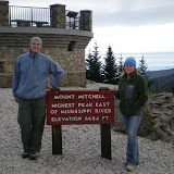
We detoured south into South Carolina for a quick walk up Sassafras Mountain, the South Carolina highpoint before getting on the Blue Ridge Parkway to head toward Asheville. We had a quick beer and dinner in Asheville, but apparently it wasn't quick enough because when we got to the campground at Mt. Mitchell State Park it was padlocked shut! We couldn't get in, and if you were already in I don't see how you could get out either! We also saw a black bear on the road going in to the park.

We continued on the Parkway for a few miles hoping there would be another campground but there was nothing out there. Eventually we gave up and ended up sleeping in the car. It was raining so camping might not have been that fun either. After 50+ days on the road, to have to sleep in the car for the first time wasn't that bad and we slept pretty well actually.

In the morning when the state park opened we drove up to Mt. Mitchell and walked the short walk to the top.


We then drove further on the Blue Ridge Parkway up into Virginia where we camped at Grayson Highlands State Park, probably the nicest campground we stayed at yet. It was super clean, there were free showers, the host was very hospitable and there were tons of trails. Plus, ponies! (Seriously, there were ponies grazing in the "high country".) We also saw another bear crossing the road.

In the morning, admist lots of rain and fog we braved eight miles (round-trip) of the Appalachian Trail to the top of Mt. Rogers, the Virginia highpoint.


We are now in Durham, North Carolina visiting several of our Seattle friends who have moved here. Durham is an interesting place. It's definitely a place of contrasts. Block to block it changes a lot and while there are some nice areas there are also some very scary areas that I definitely would not venture into at night. But overall, we're having a nice visit here. Tomorrow we head north for our final push to New England. We'll stop one night in Maryland and then it's on to the Catskills of New York for the weekend...

Here's a link to the rest of our pictures from our highpoint frenzy. Also, I have now done 34 peaks of my 35 peak challenge. I'm open to suggestions as to what the 35th peak should be. Let me know in the comments what you think...

Southern Highpoints

Sunday, September 27, 2009

Texas!

We actually got two e-mails making sure we're doing okay since we haven't posted in almost a week. We're glad to see people are following our travels and everyone can rest easy as we're doing fine and having a wonderful time! (It's good to know we have at least two fans!)

We were sad to leave Santa Fe, as we had such a good time with Asa's Aunt Debbie. We went south through New Mexico, making a quick stop in Roswell. Roswell is an interesting place, worth a drive-through, but not much else. We went to a museum there where we saw information about Robert Goddard, an early rocket engineer from the 1930s who was from Worcester, MA - interesting mainly because that's where Jaimee's family lives! It's a small world!

After camping at Brantley State Park in the Southeast corner of New Mexico we stopped at Carlsbad Caverns National Park. This is definitely worth a stop! We did the full self-guided tour through the caverns - it took us over two hours to walk the whole thing. It's a pretty neat place. It also seems to employ a lot of Park Rangers - they rove around the cavern on "Cave Watch" duty - looking for misconduct or for those who didn't "assess their hiking fitness" and need assistance.

We continued on to Guadalupe Mountains National Park in Texas which is now one of our favorite parks. It's a "wilderness park" meaning that if you don't want to hike or backpack there isn't a whole lot to do. It also contains Guadalupe Peak, the "top of Texas" at 8,749 feet. West Texas has some tall mountains! While climbing the peak we met the first, but definitely not the last Texan who was proud of his/her state. Texans love Texas, and they let you know that. I think that's great - you should love where you live.

After two peaceful nights, where our campsite hosted both skunks and deer, we traveled southeast to Big Bend National Park. Despite being about "10 hours from anywhere" it's also a great park. We camped up in the Chiso Mountains basin, the only mountain range in America to be entirely contained inside a National Park. We did a few hikes in the mountains before heading down to the Rio Grande side of the park.

I wish I had visited Big Bend prior to 2002 as that was when they began policing the border aggressively. Prior to 2002 the Rio Grande in this area was considered a "soft border crossing" meaning for a small fee a Mexican would row you across the river to one of several Mexican villages for beer and tacos. Now, the rangers follow the tourists making sure that no "Mexican Nationals" are illegally crossing over. It's pretty ridiculous - we essentially had our own escort of two law enforcement Rangers who tailed us as we went from section to section of the park. Then, when dusk came the mosquitoes were horrible! They were so bad that we didn't even cook dinner that night and just hunkered down inside the tent. We would have put our bug spray on but we'd actually just taken showers so didn't want to soil ourselves so soon!

The next morning we got up and made the long drive toward Austin. We took the "scenic route" by stopping in Del Rio, Texas and making a quick stop across the border into Mexico. This is one of the "approved" border crossings. Ciudad Acuna isn't that great, but I was able to get a $2 haircut. And we had fries and a drink for $2.50. The border patrol searched our car pretty thoroughly when we came back into America - I would have taken a picture if pictures were allowed as they let the K-9 German Shephard right into our car to sniff around. He didn't find anything although the border people did find a lot of broken glass which made them suspicious.

We broke up the pictures into two albums:
Now we're in hot and humid Austin. We just toured through the Pecan Street festival and are having a fun time here so far. But more on that later...

Thursday, September 17, 2009

The Road to Santa Fe

We encountered our first rain of the trip last night. Leaving Arizona yesterday we drove east into really dark clouds and an impressive amount of lightning. We stopped for dinner in Gallup, New Mexico where the Navajo Indians would come by the table trying to sell their jewelry.

We ended up driving out to the National Forest and found a primitive campsite and pitched our tent in the rain. The rain eventually let up during the night and we were able to pack up our tent this morning without any rain.

We crossed the Continental Divide, went through some caves at El Malpais National Monument (the Mexican Badlands) and continued on to Albuquerque. We'll tour around here a little bit before heading on to Santa Fe.

Sunday, September 6, 2009

Death Valley and Joshua Tree

Did we really go to Death Valley in the summer? Yes, and although I wouldn't necessarily recommend it, I'm glad we went. After climbing Mt. Whitney and recouperating a little at the hotel in Lone Pine, we decided to drive the 100 miles into Death Valley National Park. I knew it would be hot (average day-time highs of around 110). What we didn't know is that there was actually a mountain pass of about 5000 feet we had to climb over. And that it was more like 120 the day we vistited. We turned off the air conditioning and even though the breeze made us hotter, the car did fine. It started to inch up on the temperature gauge but it never gave us any problems.

After seeing the sights of Death Valley (like Badwater as seen in the picture on the right) and cooling off a little in the air conditioned museum, we weren't sure what to do for the night. I had actually thought that it might cool off enough in the evening and night to camp in Death Valley (aren't deserts supposed to cool down fast?) but it was averaging close to 100 all night. So, we pressed on toward Joshua Tree National Park, another 275 miles Southwest. We got to see the worlds tallest thermometer in Baker, CA (on left - it was still over 100) and somewhere near Lucerne Valley, CA we saw a pretty large fireworks display while driving. We still don't know what they were for.

We camped on the North side of Joshua Tree the first night and pitched the tent under the full moon. Although it was still warm it was nothing like Death Valley. In the morning we got up early and toured the park, including a hike of Ryan Mountain (peak #22). Then we pitched our Kelty Carport shelter and created our own shade while waiting out the heat of the day. Jaimee and I hadn't used the Carport on this trip yet, and it worked great. In fact, we were able to rig it to cover the picnic table and even slept under it instead of pitching the tent.

The next morning we got up and headed further south, going to San Diego where we are now. We're staying with our friend Jennifer, whose family lives in Seattle. She was kind enough to host us even though we gave her very little notice. We're having a great time here, and will post about it with some pictures soon.

Here are the rest of the photos from Death Valley and Joshua Tree:

Death Valley and Joshua Tree

Thursday, September 3, 2009

Climbing Mt. Whitney

We left Devils Postpile and turned south on 395 and were amazed by the beauty all around us. On the west of us were the Sierras and on the east of us were the "Alabama Hills" (filming location of the Transformer movies). The drive was through this valley and it's very hot and dry through here; the clouds get caught by each mountain range and don't dump rain in the middle. We went up to the Mt. Whitney portal. It was swarming with hikers. Even though the hike is 22 miles round-trip with 6,000 feet of elevation gain, topping out on Whitney at 14,497, it seems that most people opt to do it in one day! We, however, took two days to do it (I'll leave the one-day hike for another time).

Even with two days, one of the days has to be a long day as there isn't camping along the entire route. Here's what we did: we hiked from Whitney Portal (8,300 ft.) to Trail Camp (12,000 ft.) covering 6 miles and set up camp (picture of our little tent with our built out campsite). We actually hiked this in only four hours! This is when I started to feel beginning symptoms of altitude sickness. Jaimee felt fine, but I had the classic symptoms: headache, nausea and lack of appetite. It feels like a caffeine-withdrawal headache combined with a dose too many of NyQuil. And, since we'd hiked the first part so quickly, I had nothing to do but lie in the tent and rest and all Jaimee did was worry! Eventually, we cooked dinner, I ate some and went to bed hoping I'd feel better in the morning.

We set the alarm for 5:30AM so that we could get an early start. I was feeling a lot better. I didn't sleep super well, but my headache was mostly gone, although I still wasn't feeling very hungry. We were treated to the most incredible colors as the sun came up:

We drank some Coca tea that someone who'd visited Peru gave us (it's supposed to help with altitude sickness). We left camp with our packs only loaded with water, some food and extra layers. We started hiking around 6:15am and actually summited at 9:15am! So, for those keeping track, that's only 7 hours of hiking so far. Although tired, we both felt pretty good.


We snapped a few photos at the top, signed the trail register and headed down around 10am. Lucky that we left when we did; the clouds were ominously building up around the summit and lightning can be a real danger up there. We got back to our camp and made a quick hot meal as on the way up neither of us had been that hungry so we didn't eat much on the way up. Then we packed up our camp and proceeded back down to the portal area. Never have 6 miles seemed so long, but eventually we made it. We ended up hiking 16 miles that day, and as Jaimee likes to say, she thinks her shoes have a "12, maybe 13 mile limit" for comfort.

The thought of camping again, and especially eating camp food made both our stomachs churn so we went back to the town of Lone Pine, CA (elevation 3,700 ft.) and found a hotel and ate in a restaurant, neither of which we'd done much on this trip so far. We capped the adventure off with two frosty beers and a game of Scrabble.


Now, we're contemplating where to go next. We're going to LA next week, but we have the weekend without any firm plans. We're going to head over to Death Valley for one night at least since it's only 100 miles away, but after that we don't know. So, the adventure continues...

Here's the full slideshow of our climb:

Monday, August 31, 2009

Yosemite and Devils Postpile

After we left the San Francisco area, we weren't sure when we'd have Internet again, but being as this is California we found the Internet in a little bagel shop in Mammoth Lakes. We drove from Los Gatos to Yosemite, but because of a "prescribed" forest fire that went from burning 90 acres to over 3,500 acres parts of the park were closed. The entire "Yosemite Valley" was closed to cars. Since we were heading across the Sierras we had to take the Tioga Pass road through the northern section of the park.

This meant we missed El Capitan and Half-Dome. But there was some really cool scenery along the road. We camped at White Wolf campground for one night and did a day-hike of Lembert Dome near Tuolumne Meadows the next day.

Then we headed toward Mammoth Lakes on and went to Devils Postpile National Monument for the night. The Postpile was pretty cool and this morning before stopping at this bagel shop we took hot spring showers.

Here's the slideshow of the two parks:


Now we're off to the Whitney Portal for our climb on Tuesday.

Thursday, August 27, 2009

Crater Lake

From Bend we traveled about two hours south to Crater Lake National Park. We went there two years ago on a big road trip we took visiting western National Parks. When we visited last time we camped backcountry along the Pacific Crest Trail away from the actual lake. This time we camped in one of the park's campgrounds for two nights.

We also took a boat tour of the caldera lake including a visit to Wizard Island. We had amazing weather, we climbed three peaks and had a very nice time visiting pretty much all parts of this great park. We left Crater Lake and traveled to San Francisco where we're staying in a few different places visiting friends before we head out to the Mt. Whitney area in preparation for our climb next Tuesday.

Here's a slideshow of our stay in Crater Lake:

Tuesday, August 18, 2009

Seattle to the Enchantments

We are now officially on the road! We left Seattle on Saturday August 15 around 9:30AM. We said good-bye to our wonderful friends Greg & Laura, who had so graciously let us stay with them for the past two weeks, and after doing a few last-minute errands, we headed out for three days of backpacking in the Enchantments, near Leavenworth, WA.

Over the last two weeks we'd been saying our last good-byes to our favorite Seattle people and places. I have lived in Seattle since 1995 and will always love it.

We drove from Seattle to the Snow Lake trail head for our trip to the Enchantments. For those not familiar with this area, it's a Wilderness Area in central Washington encompassing several glacier lakes. We used upper Snow Lake as a base camp and spent two nights there with a day hike on the second day to Aasgard Pass. Here is a brief map of the area, showing the "zones" and rough geography of the area.

The hike to Snow Lake was about 7 miles with 4,000 feet of elevation gain, and the day hike to Aasgard Pass was roughly another 8 or 9 miles (one-way!) with 3,400 feet of elevation gain. It was a very tiring few days, but the scenery was amazing, including lots of mountain goats. I won't go so far as to say it's the most beautiful hiking in Washington, but it probably does rank right up there.

Here's slideshow of the trip. (Although I will say these pictures do not do the place justice. See pictures from my friends Kyle and Daniel who did the whole loop last year).


Now we are resting up from our hike at Jaimee's Aunt and Uncle (and Mom now too)'s house in Kamiah, ID. On tap for this week is floating down the river, and getting ready for our future WWOOFing by helping out on the "farm" around here. Jaimee's Aunt has 34 chickens and a huge garden.
Related Posts with Thumbnails