Showing posts with label national parks. Show all posts

Friday, May 28, 2010

A Cretan Adventure

When we decided to visit Greece, we didn't really know where we'd end up going. With 227 inhabited islands (thank you Wikipedia), plus numerous places to visit on the mainland it was a bit daunting to decide where to go. We chose Rhodes to start because it was close to Turkey, but from there we had many choices. We're definitely glad we added Crete to our itinerary.

Crete is the largest of the Greek islands by both population and area. Most of the people live along the northern coast, and we landed off the ferry in Iraklio, around the center of the north coast. Although a definite stop on the tourist trail, Iraklio had a sort of rundown feel to it. There was graffiti everywhere, and there were many beggars and street kids trying to sell us stuff as we walked around.
From Crete
Now is the part of the blog where we describe things that we didn't go to see; The Archaeological Museum is apparently quite nice, and the Palace of Knossos is the main tourist attraction of Iraklio. Unfortunately we didn't go to either. We did try to go the Battle of Crete Museum, but it was closed. (I read a little about the Battle of Crete, which took place from May 20 to June 1, 1941 when Germany invaded and "conquered" Crete during World War II, and I was hoping for pictures of the famed glider troopers that Germany used in the battle.) There's also the Cretaquarium (a great name for an aquarium, by the way), "the largest aquarium in the Eastern Mediterranean." Which begs the question, does this mean it's large or small? I assume they mean to imply it's large, but really, how many aquariums can there be in the Eastern Mediterranean?

Anyway, after enjoying a few of the numerous street-side cafes in Iraklio (and honing our backgammon skills) we moved on to our couchsurfing hosts of Irene and Arjan in the small village of Koutouloufari, about 15 miles east of Iraklio. Hoping to couchsurf on Crete we had sent a message to the general Crete couchsurfing group. This was a new method for us to find a host. Normally, the way couchsurfing works is that a surfer (one who wants to stay with someone else) does a search in a given area for hosts and then messages them each individually requesting to stay. However, all the people we requested to stay with were unable to host us for one reason or another. So we sent a message to the Crete Couchsurfing Group saying we were on Crete, didn't know where we wanted to go and wondered if anyone wanted to host us.

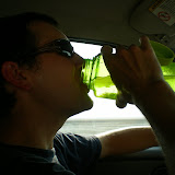
Luckily, Irene messaged us and said she'd love to host us. It couldn't have turned out better. Irene is from the Netherlands, having moved to Crete only five or six weeks ago. She moved in with her Dutch boyfriend who's summered here for the past 15 summers. They are relatively new to couchsurfing (we were only their second guests) but they were outstanding hosts. We had our own little apartment, on the second floor of an impossibly cute little Greek house. Additionally, Irene is a chef and she cooked us a delicious vegetarian meal the first night we were there. Here's Jaimee relaxing in our little room:
From Crete
Irene's boyfriend Arjan runs a tour business, called Routaki Routes where he provides customized driving routes all over Crete. There's an audio portion where you listen to information at each "stop" of the route. He drives the routes periodically to make sure they're up-to-date and he took us one of the off-road trips in his jeep and it was a blast. We went all over the mountains of Crete, saw many vineyards, orange groves, churches, a huge agave plant, and a giant cave! He wrote the trip up on his blog (even written in English for those of us who don't read Dutch). Here we are in front of one of the churches on the route:
From Crete
We ended up having dinner at this farm/hotel which we never would have found otherwise, and had a wonderful gourmet meze meal (Greek style tapas) of over 10 different dishes.

It was hard to leave Irene and Arjan, but we took a bus across the island to Chania in western Crete. It was there another couchsurfer (Juan, from Spain) agreed to host us. We had contacted him individually from an earlier couchsearch and his "maybe" turned in an "accepted" while we were staying with Irene and Arjan. We wanted to visit western Crete primarily to hike Samaria Gorge, and this turned out to be a highlight, not just of Crete, but of our entire trip. It's listed as being of varying lengths (from 13km to 18km [8 to 11 miles]), depending on where you measure the start and end but it is invariably listed as the "longest gorge walk in Europe". (Similar to the Cretaquarium discussion above, I wondered, how many gorge walks are there in Europe?) Regardless, it was both long and beautiful.

The standard route is to take a bus to the start at the northern end which begins at 1,250 meters (4,100 feet) and walk down through the gorge to the sea. Then catch a ferry to another town where you catch a different bus back to Chania. In all, it was a 13 hour day, but totally worth it. We took some photos during our hike, which you can see at the end of our Crete album but there are some good ones on the Samaria Gorge information page as well.

Now we're off to Athens. We weren't sure if we were going to go to Athens or not, but the only ferries from Chania go to Athens. We are couchsurfing in Athens as well, and we're supposed to meet up with our host for breakfast tomorrow morning. The ferry leaves at 11PM and gets into Athens (Piraeus) around 6AM. We bought "deck" class tickets (no inside cabin) but it's a full moon and we hope (well, I do at least) to pull out our sleeping bags and sleep outside on the deck.

Friday, January 22, 2010

Stewart Island

After our wonderful week WWOOFing with Ellen and Colin we headed to Stewart Island for a couple nights. It was a bit of an ordeal to get there, as Colin dropped us off in Winton where we caught a bus into Invercargill, then a different bus to Bluff and then an hour ferry to the island. The ferry crossing was pretty rough, but relatively short so we got to Stewart Island mid-morning on Wednesday.


The main town of Oban is a sleepy little village with one main hotel, a small grocery store, a couple of backpacker hostels and a fish and chip shop. After checking into the hostel we wandered down to the library; we love visiting public libraries as there is usually free Internet and the one in Oban didn't disappoint, except that it is only open four hours a week! We felt lucky to be there during one of their four open hours!

Supposedly summer is the peak tourist season but the town didn't seem very overwhelmed with tourists, although the cold, rainy weather might have contributed to the lack of people. We had one full day on the island so we decided that rain or shine we'd go for a hike. Although it rained overnight and was overcast when we started, the weather turned out beautiful. We hiked the beginning of the Rakiura Track, one of New Zealand's Great Walks. The trail begins with a walk under a huge chain which represents Steward Island as the anchor of the country.


The full walk is a 36km (22mi) loop with huts along the way. We hiked the portion of it out to Maori Beach. Even though we didn't start that early (9am) we had the beach to ourselves.

Of course, this is a New Zealand beach so we didn't swim, and the sand flies were terrible, but it was quite pretty.


On the way back to took "the long way" back to town and walked around Horseshoe Point where we watched the fog rolling in for the afternoon.


The next day we took the ferry back to Bluff (a much calmer ride), the connector bus to Invercargill and then a long-distance bus up to Christchurch where we are now. We're back staying with Sue and her family where we couchsurfed before. Although Sue only signed up for couchsurfing mid-December she's really jumped on it. She's hosting us, another couple from Alaska and a man from Spain - all at the same time! Sue took us out dancing last night and today we might go pick blueberries with her (although not at Blueberry Bliss - she did stop in there the day we left but doesn't like the picking there because she claims the bushes are really picked over) . We're in Christchurch through Monday. We hope to check out the Busker Festival, although the weather is not cooperating; it's overcast, raining and actually pretty cold (53F).

Here's the link to the full set of Stewart Island pictures:
Stewart Island

Saturday, January 2, 2010

Waiting out the rain

It is pouring down buckets of rain right now so we're waiting it out at our hostel in Fox Glacier along the West Coast of the South Island. After escaping from Jack's we rented a car in Westport for a tour of the South Island. It's been really fun and we've seen a ton. We won't recount every step of the way, but you can browse through the pictures here:

South Island Roadtrip Part I

One of the highlights for sure was our visit to Aoraki/Mount Cook National Park. As we mentioned briefly in our New Year's post, we spent two nights at the New Zealand Alpine Club lodge over New Year's. It was windy and cloudy over the mountains for most of our visit, but on the morning we left, Mount Cook was visible:


It's an amazing sight, and then as we were driving away we stopped for more pictures at a viewpoint:

We went to Queenstown for a night, and wow was it packed with tourists. All the hostels were full so we ended up renting a tent for the night and camping at a campground in town. We can't believe how they pack people into the campgrounds here. It's pretty standard to put caravans and tents right next to one another. And it's not cheap! It would have been nice to get out in the backcountry here but we don't really have the right equipment (i.e., no stove, tent) and to stay in a hut costs about 50% more than staying in a hostel.

We're enjoying the West Coast as it's less touristy and when it's not raining (about half the time) the views and walks are great. We also had fun picking up hitchhikers yesterday. We gave a Swiss kid a ride (he was a former UN soldier in Africa) and then we drove these two teenagers across the island. They were doing what they called the "amusing race" where two teams of two were racing around the island only by hitchhiking. Ah, what crazy stuff the NZ youth do! We thought it was funny that they even stopped with us and walked down to a waterfall along the way:

We'll be back in Westport by Tuesday to return the car, then we're taking the TranzAlpine train across the island to Christchurch. It's supposed to be super scenic, and although we've already driven the road across, the train follows a different route.

And, in other news, we've booked our tickets out of New Zealand. We have been watching fares from New Zealand to Southeast Asia and the tickets we bought seem like a good deal. We're flying out of Christchurch on the South Island so we don't have to travel back to Auckland which is good. We fly to Singapore for five nights on January 25, then on to Kuala Lumpur in Malaysia on the 30th. You can check our finance and calendar pages for more details. We've already sent out some couchsurfing requests for both Singapore and Kuala Lumpur. It actually looks like there are some cool hosts in both places.

Given that we have three more weeks in New Zealand we're going to try and WWOOF one more time before we leave. We have some leads on farms in the south. But if that doesn't work out, we're enjoying being tourists.

Monday, November 16, 2009

Climbing Kosciuszko

As mentioned in our previous posts we planned on climbing Mt. Kosciuszko, the highest point in Australia on our roadtrip from Brisbane to Melbourne. Well, we're happy to report that we succeeded!

Continuing from our last post, we drove south down the coast toward Sydney and camped at Crowdy Head National Park, a secluded ocean-front park. We had to drive about 10 miles on a dirt road to get to the camp ground and since we didn't see any other vehicles we thought we'd have the campground to ourselves. We were surprised when we turned into the campground and it was pretty full. And they charged $10 per person per night! This is in contrast to US National Parks which almost always charge only per site, and never more than say $20. But, there were free showers which we took advantage of the next morning. We also enjoyed watching the kangaroos interacting with the other campers:


The next morning when we drove around Sydney we got stuck in quite a bit of traffic. There are a few toll roads in Australia but very few of them take cash; you need a transponder in your car to ride on them. Since we didn't have one we had to take surface streets around Sydney. Eventually we found our way out of the city and started heading west toward Mt. Kosciuszko.

We camped at a rest stop outside Australia's capital, Canberra, which is also near some of Australia's wine country. We were able to visit a winery on our way the next day but some of the other wineries we tried to visit were closed, as was a brewery! I guess it's sort of "shoulder season" here between Winter and Summer.

We got to the Mt. Kosciuszko area which is a National Park, even though there are several ski resorts inside the park. (As a side note, you have to pay per day to enter the park, which was $16 per day per car. Unlike the USA where paying a National Park entry fee generally allows you to stay for seven days.) We parked the van in a secluded spot where we had kangaroos and pygmy possums visiting us during the night.

We drove up to Charlotte Pass (one of the ski areas) to start our hike. It was a pretty easy hike, walking along a flat trail that used to be a car road. The hike was 18km (about 11 miles) round trip with about 468 meters (about 1500 ft) of elevation gain. It was really beautiful scenery. Here we are at the top:


It seems most people who climb Kozi (as they call it here) take a chairlift part of the way up. But not us. Plus, it cost $29 each to take the chairlift!

The drive from Kozi into Victoria and Melbourne took us another day and a night. We camped by a river and after a long day of driving today arrived in Melbourne in the afternoon. We're staying in Williamstown, a cozy suburb of Melbourne at the grand parents of Yael. They're super nice and plan on showing us a few sights around here the next few days.

Here's a link to the rest of the pictures of our Kozi hike.
Kosciusko

Wednesday, October 7, 2009

Six peaks, four days

We settled up the bill at our hotel in New Orleans. Somehow the $45 per night hotel ballooned into $76 after adding in all the taxes and fees! Apparently Louisiana state law requires safes in all hotel rooms and hotels charge $4 per night for this? That was just one of the many hidden fees charged. I felt a bit duped with all the extra taxes and fees, but we were glad to see more of New Orleans. It's a great city and one that I hope to visit again in more depth some other time.

From New Orleans we cruised through Mississippi and most of Alabama to camp at Cheaha State Park in northeast Alabama. We got there right as it was getting dark and we found the campground to be a little difficult to figure out. There was an area for RVs but the tent area was labeled "semi-primitive" without designated camping sites. Plus there was a group of American Heritage Girls building fires and roasting marshmellows all over the area. Although the one group leader seemed very nice (they're so polite in the South) we decided to go back to the RV area and pitch our tent in a RV spot.

The next day we got up and climbed the 75 foot tower marking the highpoint of Alabama.


We also discovered the other tent camping area lining the road leading to the tower. But again, there were no designated sites. People just pulled their cars over and camped on the side of the road. I've seen more orderly homeless people in Seattle.

We left Alabama and crossed over into Georgia, seeking out the highpoint of Georgia. There was a road almost to the top, but it was a 6/10 of a mile walk to the actual highpoint.


From Georgia we headed into the Smokies, camping for a night at Great Smoky Mountain National Park. This is the busiest National Park in the country and October is the second busiest month of the year (after July) although we did find a spot in the campground. In the morning we drove up to Clingmans Dome, the highpoint of Tennessee, and also the highest point on the Appalachian Trail. I thought the structure they built on the top was pretty ugly and wouldn't mind seeing them tear it down to make the highpoint more natural.


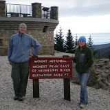
We detoured south into South Carolina for a quick walk up Sassafras Mountain, the South Carolina highpoint before getting on the Blue Ridge Parkway to head toward Asheville. We had a quick beer and dinner in Asheville, but apparently it wasn't quick enough because when we got to the campground at Mt. Mitchell State Park it was padlocked shut! We couldn't get in, and if you were already in I don't see how you could get out either! We also saw a black bear on the road going in to the park.

We continued on the Parkway for a few miles hoping there would be another campground but there was nothing out there. Eventually we gave up and ended up sleeping in the car. It was raining so camping might not have been that fun either. After 50+ days on the road, to have to sleep in the car for the first time wasn't that bad and we slept pretty well actually.

In the morning when the state park opened we drove up to Mt. Mitchell and walked the short walk to the top.


We then drove further on the Blue Ridge Parkway up into Virginia where we camped at Grayson Highlands State Park, probably the nicest campground we stayed at yet. It was super clean, there were free showers, the host was very hospitable and there were tons of trails. Plus, ponies! (Seriously, there were ponies grazing in the "high country".) We also saw another bear crossing the road.

In the morning, admist lots of rain and fog we braved eight miles (round-trip) of the Appalachian Trail to the top of Mt. Rogers, the Virginia highpoint.


We are now in Durham, North Carolina visiting several of our Seattle friends who have moved here. Durham is an interesting place. It's definitely a place of contrasts. Block to block it changes a lot and while there are some nice areas there are also some very scary areas that I definitely would not venture into at night. But overall, we're having a nice visit here. Tomorrow we head north for our final push to New England. We'll stop one night in Maryland and then it's on to the Catskills of New York for the weekend...

Here's a link to the rest of our pictures from our highpoint frenzy. Also, I have now done 34 peaks of my 35 peak challenge. I'm open to suggestions as to what the 35th peak should be. Let me know in the comments what you think...

Southern Highpoints

Sunday, September 27, 2009

Texas!

We actually got two e-mails making sure we're doing okay since we haven't posted in almost a week. We're glad to see people are following our travels and everyone can rest easy as we're doing fine and having a wonderful time! (It's good to know we have at least two fans!)

We were sad to leave Santa Fe, as we had such a good time with Asa's Aunt Debbie. We went south through New Mexico, making a quick stop in Roswell. Roswell is an interesting place, worth a drive-through, but not much else. We went to a museum there where we saw information about Robert Goddard, an early rocket engineer from the 1930s who was from Worcester, MA - interesting mainly because that's where Jaimee's family lives! It's a small world!

After camping at Brantley State Park in the Southeast corner of New Mexico we stopped at Carlsbad Caverns National Park. This is definitely worth a stop! We did the full self-guided tour through the caverns - it took us over two hours to walk the whole thing. It's a pretty neat place. It also seems to employ a lot of Park Rangers - they rove around the cavern on "Cave Watch" duty - looking for misconduct or for those who didn't "assess their hiking fitness" and need assistance.

We continued on to Guadalupe Mountains National Park in Texas which is now one of our favorite parks. It's a "wilderness park" meaning that if you don't want to hike or backpack there isn't a whole lot to do. It also contains Guadalupe Peak, the "top of Texas" at 8,749 feet. West Texas has some tall mountains! While climbing the peak we met the first, but definitely not the last Texan who was proud of his/her state. Texans love Texas, and they let you know that. I think that's great - you should love where you live.

After two peaceful nights, where our campsite hosted both skunks and deer, we traveled southeast to Big Bend National Park. Despite being about "10 hours from anywhere" it's also a great park. We camped up in the Chiso Mountains basin, the only mountain range in America to be entirely contained inside a National Park. We did a few hikes in the mountains before heading down to the Rio Grande side of the park.

I wish I had visited Big Bend prior to 2002 as that was when they began policing the border aggressively. Prior to 2002 the Rio Grande in this area was considered a "soft border crossing" meaning for a small fee a Mexican would row you across the river to one of several Mexican villages for beer and tacos. Now, the rangers follow the tourists making sure that no "Mexican Nationals" are illegally crossing over. It's pretty ridiculous - we essentially had our own escort of two law enforcement Rangers who tailed us as we went from section to section of the park. Then, when dusk came the mosquitoes were horrible! They were so bad that we didn't even cook dinner that night and just hunkered down inside the tent. We would have put our bug spray on but we'd actually just taken showers so didn't want to soil ourselves so soon!

The next morning we got up and made the long drive toward Austin. We took the "scenic route" by stopping in Del Rio, Texas and making a quick stop across the border into Mexico. This is one of the "approved" border crossings. Ciudad Acuna isn't that great, but I was able to get a $2 haircut. And we had fries and a drink for $2.50. The border patrol searched our car pretty thoroughly when we came back into America - I would have taken a picture if pictures were allowed as they let the K-9 German Shephard right into our car to sniff around. He didn't find anything although the border people did find a lot of broken glass which made them suspicious.

We broke up the pictures into two albums:
Now we're in hot and humid Austin. We just toured through the Pecan Street festival and are having a fun time here so far. But more on that later...

Thursday, September 17, 2009

The Road to Santa Fe

We encountered our first rain of the trip last night. Leaving Arizona yesterday we drove east into really dark clouds and an impressive amount of lightning. We stopped for dinner in Gallup, New Mexico where the Navajo Indians would come by the table trying to sell their jewelry.

We ended up driving out to the National Forest and found a primitive campsite and pitched our tent in the rain. The rain eventually let up during the night and we were able to pack up our tent this morning without any rain.

We crossed the Continental Divide, went through some caves at El Malpais National Monument (the Mexican Badlands) and continued on to Albuquerque. We'll tour around here a little bit before heading on to Santa Fe.

Wednesday, September 16, 2009

Flagstaff

After a wonderful visit in Tucson, we left and headed north, making our way to Flagstaff, Arizona. We decided to take the scenic route through Prescott and Sedona. It made for a beautiful drive, much prettier than we thought it would be. Prescott is a charming, historic town. We walked around and admired the old courthouse on the tree-lined square.

Then we continued on to Sedona, driving this wild road that had, according to T-shirts we saw for sale in Jerome (a town along the way), 158 curves in 12 miles. We didn't count the curves, but it was a crazy road. Jerome is a cute town, built right on the bluffs of the red rocks. We tried getting a picture of the houses right on the edge but couldn't get one that captured the steepness of the town. Definitely worth a visit if you're ever in the Sedona/Prescott area.

Sedona was a nice town as well. Although the town itself is very touristy and has a real resort feel (something like Whistler, BC in the summer) the area is amazingly beautiful. We only stopped briefly as our couchsurfers in Flagstaff were expecting us.

We got to our couchsurfer host's house right in time for margaritas and guacamole made with freshly picked prickly pear cactus fruit! Our host Scott boiled the fruit and blended it to make a syrup. The fruit itself has the texture of dates and the taste is a combination of sweet and sour. It's very good, especially with tequila!


The next day we hiked up Mt. Humphreys, which at 12,633 ft. is the highest peak in Arizona. The trail starts from Arizona Snowbowl, a ski area which is above 9,000 ft. so the hike wasn't too bad of a climb.
While on the top of the peak we met a man who said this was his 73rd time climbing Humphreys! He'd lived in the Flagstaff area all his life and said he started "seriously keeping track after his 10th time." He'd been climbing it since 1974.

Our couchsurfing hosts, Scott and Amanda were great. They had a really cute dog named "Moondog" which apparently was her breed as well. We certainly don't know what kind of dog she is. Scott also liked to ride his custom fixed gear bike with Moondog on his side. His bike was a $5 Huffy that he converted to be a fixed gear bike. He called it a "fixed-gear truck" which we thought seemed appropriate in Flagstaff. Scott was also a really good Scrabble player and schooled me and Jaimee twice!


We left Flagstaff and cruised up to the "Meteor Crater". They wanted $15 per person to view this crater but we got a perfectly good picture right from the information sign!

Then we went through Petrified Forest National Park. The park was pretty much what you'd expect - a bunch of petrified wood, although there were also some beautiful overlooks and a "painted desert." We saw some Indian artifacts and petroglyphs and an old Indian pueblo.

Here are all the photos for Flagstaff:


Originally, we'd intended to go to Taos, New Mexico from Flagstaff, but we got a late start leaving Flagstaff so we're now in Gallup, New Mexico looking for somewhere to camp. Hopefully it won't rain on us as it's very stormy outside. Tomorrow we head to Santa Fe to visit my Aunt Debbie. Maybe we'll fit Taos in during our Santa Fe visit.

Monday, September 14, 2009

Tucson

From Los Angeles we drove about 500 miles southeast to Tucson. We stayed with Lou and his wife Nancy, old friends of mine I used to know when I lived in Vermont. It's really beautiful here. Although it's very hot during the day (above 100 every day) there are frequent storms, and it even rained for a couple hours one night. We saw many lighting storms in the distance.

We spent two relaxing days touring around Tucson. We went to Saguaro National Park, which although beautiful was a little underwhelming when compared to the other National Parks we've been to. But we did see huge fields of Saguaro cacti, as pictured on the right. They grow extremely slowly, taking maybe 60 years to grow to a height of six feet.

Our hosts were kind enough to give us guest passes to the Desert Museum which was actually more like a zoo. We saw bobcats, wolves, prairie dogs, all sorts of birds (there were two different aviaries, including one just for hummingbirds) and other animals that I didn't know lived in the desert, like beavers!

We also explored downtown Tucson, which was a very strange place. Apart from the University of Arizona area, which seemed busy (we went by right before a football game), the rest of the town was pretty low-key. We wandered around on a Saturday afternoon and most stores were closed or out of business. I don't know if it's that there are so many half-time residents (who aren't quite back yet for the winter) or that so many older retirees don't visit downtown (even though there is free parking on the weekends), but it had a very ghost-town-like appearance. The only thriving businesses seemed to be Mexican barbershops and taco stands (that's two different stores).

Here's the full slideshow of our Tucson visit:


We had a great visit, catching up with Lou and Nancy, whom I hadn't seen in over 10 years. Tucson is a very interesting place, both culturally and geographically. Now we're heading north to Flagstaff. We've arranged to stay with the couchsurfing "ambassador" of Flagstaff and apparently there are guests from England staying there as well, so it should be a full house. Our plan is to climb Mt. Humphreys tomorrow. Stay tuned for the full report.

Sunday, September 6, 2009

Death Valley and Joshua Tree

Did we really go to Death Valley in the summer? Yes, and although I wouldn't necessarily recommend it, I'm glad we went. After climbing Mt. Whitney and recouperating a little at the hotel in Lone Pine, we decided to drive the 100 miles into Death Valley National Park. I knew it would be hot (average day-time highs of around 110). What we didn't know is that there was actually a mountain pass of about 5000 feet we had to climb over. And that it was more like 120 the day we vistited. We turned off the air conditioning and even though the breeze made us hotter, the car did fine. It started to inch up on the temperature gauge but it never gave us any problems.

After seeing the sights of Death Valley (like Badwater as seen in the picture on the right) and cooling off a little in the air conditioned museum, we weren't sure what to do for the night. I had actually thought that it might cool off enough in the evening and night to camp in Death Valley (aren't deserts supposed to cool down fast?) but it was averaging close to 100 all night. So, we pressed on toward Joshua Tree National Park, another 275 miles Southwest. We got to see the worlds tallest thermometer in Baker, CA (on left - it was still over 100) and somewhere near Lucerne Valley, CA we saw a pretty large fireworks display while driving. We still don't know what they were for.

We camped on the North side of Joshua Tree the first night and pitched the tent under the full moon. Although it was still warm it was nothing like Death Valley. In the morning we got up early and toured the park, including a hike of Ryan Mountain (peak #22). Then we pitched our Kelty Carport shelter and created our own shade while waiting out the heat of the day. Jaimee and I hadn't used the Carport on this trip yet, and it worked great. In fact, we were able to rig it to cover the picnic table and even slept under it instead of pitching the tent.

The next morning we got up and headed further south, going to San Diego where we are now. We're staying with our friend Jennifer, whose family lives in Seattle. She was kind enough to host us even though we gave her very little notice. We're having a great time here, and will post about it with some pictures soon.

Here are the rest of the photos from Death Valley and Joshua Tree:

Death Valley and Joshua Tree

Monday, August 31, 2009

Yosemite and Devils Postpile

After we left the San Francisco area, we weren't sure when we'd have Internet again, but being as this is California we found the Internet in a little bagel shop in Mammoth Lakes. We drove from Los Gatos to Yosemite, but because of a "prescribed" forest fire that went from burning 90 acres to over 3,500 acres parts of the park were closed. The entire "Yosemite Valley" was closed to cars. Since we were heading across the Sierras we had to take the Tioga Pass road through the northern section of the park.

This meant we missed El Capitan and Half-Dome. But there was some really cool scenery along the road. We camped at White Wolf campground for one night and did a day-hike of Lembert Dome near Tuolumne Meadows the next day.

Then we headed toward Mammoth Lakes on and went to Devils Postpile National Monument for the night. The Postpile was pretty cool and this morning before stopping at this bagel shop we took hot spring showers.

Here's the slideshow of the two parks:


Now we're off to the Whitney Portal for our climb on Tuesday.

Thursday, August 27, 2009

Crater Lake

From Bend we traveled about two hours south to Crater Lake National Park. We went there two years ago on a big road trip we took visiting western National Parks. When we visited last time we camped backcountry along the Pacific Crest Trail away from the actual lake. This time we camped in one of the park's campgrounds for two nights.

We also took a boat tour of the caldera lake including a visit to Wizard Island. We had amazing weather, we climbed three peaks and had a very nice time visiting pretty much all parts of this great park. We left Crater Lake and traveled to San Francisco where we're staying in a few different places visiting friends before we head out to the Mt. Whitney area in preparation for our climb next Tuesday.

Here's a slideshow of our stay in Crater Lake:

Related Posts with Thumbnails